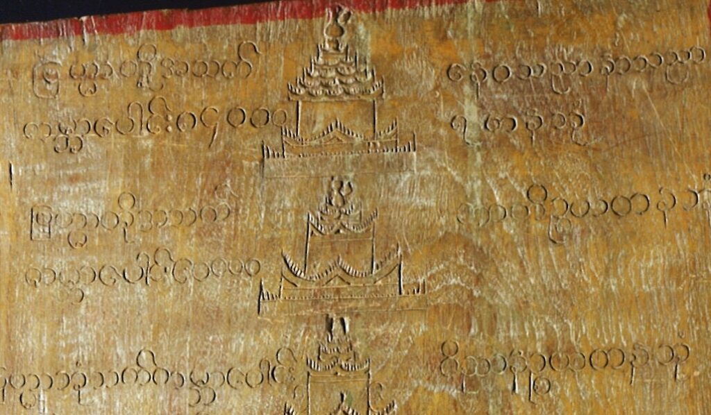
The top of the 31 levels of existence, as seen on the cosmography. Photo: John Hessler. Geography and Map Division.
This is a guest post by John Hessler, a specialist in the Library’s Geography and Map Division, focusing on computational geography and geographic information science. He’s also the Library’s curator of the Jay I. Kislak Collection.
Recently, the Library’s Geography and Map Division acquired a rare 18th-century carving of a Theravãda Buddhist cosmography that originated in Myanmar (formerly known as Burma).
The panel, which is more than 9 feet high when its three parts are fully assembled, shows the many levels that are the temporary resting places for living beings as they make their way to the ultimate goal of nirvana. The carving shows the levels that spiritual entities — humans, animals or gods – transmigrate. It pictures these way stations as floating palaces. It gives their names, the geography of the cosmos and the life of beings who temporarily reside in each of them.
The teachings of the Guatama Buddha, from which the engravings on the panel ultimately derive, are found in a series of writings that are known as the Pali Canon. These are the earliest written records of Buddhist scriptures, which had previously been handed down in the oral tradition. This large body of texts, written in the ancient Indian language of Pali, is divided into discourses of various lengths. It treats the metaphysics, psychology and cosmology of the Buddhist path toward enlightenment through meditation.
“In the sky, there is no distinction of east and west; people create distinctions out of their own minds and then believe them to be true,” is one of the Buddha’s metaphysical sayings.
The information found on the engraving in the Library’s collections does not derive from a single source, but from a variety of texts in what is called the “Sutta Pitaka,” or Basket Discourse. Most of the information inscribed on the panel can be traced to the “Majjhima Nikaya, Anguttara Nikaya, Samyutta Nikaya,” which are the middle length, numerical, and connected discourses of the Buddha, respectively.
I recently translated the panel. It describes, both graphically, as temples, and in writing, the 31 levels of existence. It starts at the top of the panel with “neither-perception-nor-non-perception.”
This is the realm of beings that are formless and without physical or material structure and who have no perception. The engraving continues down through the various levels of “Arupaloka” (world of non-form), through “Rupaloka” (world of form) into “Kãmaloka” (world of desire) finally reaching “Manussa” (the level of human beings). Below that we find the levels occupied by animals and the fiery hells that are undesirable places for rebirth and reincarnation.
In the center of the panel are carvings of temples signifying each of the levels rising from the base of Mount Meru, or the sacred mountain.
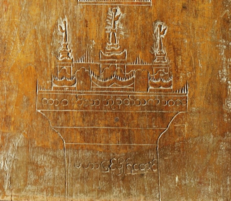
Palace at the base of Mount Meru. Photo: John Hessler. Geography and Map Division.
Here, the engraving turns cartographic.
The myth of Mount Meru is common to almost all ancient Indian religions and is part of the foundations of Hindu, Jain and Buddhist cosmology. According to all three, it is located in the center of the universe. In Hinduism, it is the realm of the gods.
In this section of the panel, we see the various mountain ranges that surround Mount Meru. These seven “golden” ranges are known as the “Sattaparibhanda.” They are separated by vast oceans.
Moving out from the center of the panel in both directions, they extend great heights and distances:
Yugandhara 40,000 yojana high and thick
Isadhara 20,000 yojana high and thick
Karavika 10,000 yojana high and thick
Sudassana 5000 yojana high and thick
Nemindhara 2500 yojana high and thick
Vinataka 1250 yojana high and thick
Asskanna 625 yojana high and thick
“Yojana” is an ancient Indian scale of measurement. It equals the distance that a cow yoked to a cart can walk in one day, although no one knows how far that actually is. The scale of these distances is not terrestrial, but cosmic. The distance from the center of Mount Meru (itself being 80,000 yojana wide) to the edge of the map is approximately 795,300 miles.
The four continents of Buddhist geography that includes earth, the “Jumbudvipa,” is in a great ocean that lies far off the map.
Theravãda Buddhism is the oldest and the only surviving form that derives directly from the ancient Hinayaba School. The word Theravãda, in both Pali and in Sanskrit, means “the School of the Elders.” It was established in Sri Lanka in the third century BCE by the Indian Emperor Asoka. Asoka’s edicts survive as some of the oldest written inscriptions relating to Buddhism, carved on boulders, pillars and cave walls, written in the ancient Brahmi script, according to Richard Salomon’s book “Indian Epigraphy.”
Although this may not seem to be a “map” in the classical Western sense, the Geography and Map Division strives to collect a wide range of cartography, cosmography and the mapmaking arts from around the world. This panel, and many others like it from cultures around the world, constantly remind us how difficult it is to actually answer the question: What is a map?
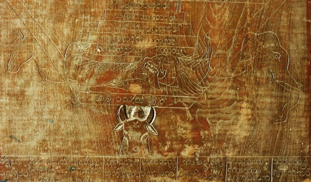
The lower realms representing the existence of animals. Photo: John Hessler. Geography and Map Division.
Subscribe to the blog— it’s free! — and the largest library in world history will send cool stories straight to your inbox.